
The Common Land, or, Five Acres I Am Honored to Describe
Behind the sixteen homes is 5.04 acres of protected woodland — Open Space Parcel C, known to the City as 100 Pond View Lane. The association owns it, every owner may use it, and a web of recorded obligations governs it. It is, if a page may say so, the true aristocracy of this neighborhood’s paper: the homes have deeds, but the woodland has perpetuity — and yet even the woodland, I notice, arranges itself around the householders, wrapping their lots on nearly every side like a court in attendance. The land knows whom it serves. I aspire to its clarity on the point.
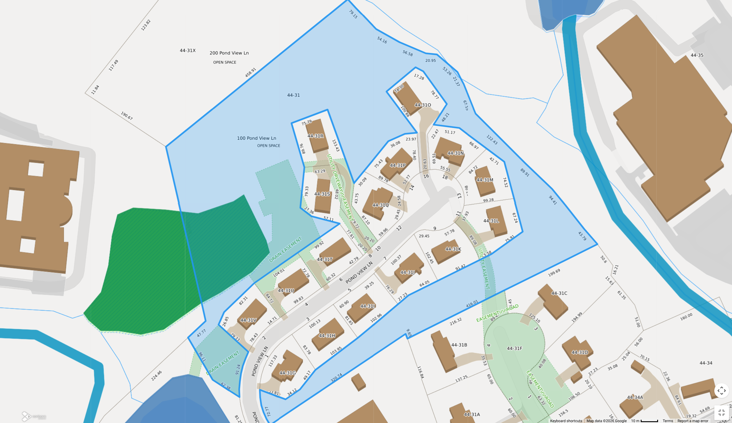 The parcel itself, sir, and I present it first because it outranks everything
else on this page: Parcel C in blue —
100 Pond View Lane, parcel 44-31 — wrapping the sixteen house lots on nearly
every side, with the separate 200 Pond View open space (44-31X) at the upper
left and Kelleher Pond at the lower left. Note which shape does the wrapping;
the homes are the ones surrounded. Screening layers are approximate; the
authoritative boundary is the one drawn on the
recorded subdivision plan, before which
I remove my hat, having no hat.
The parcel itself, sir, and I present it first because it outranks everything
else on this page: Parcel C in blue —
100 Pond View Lane, parcel 44-31 — wrapping the sixteen house lots on nearly
every side, with the separate 200 Pond View open space (44-31X) at the upper
left and Kelleher Pond at the lower left. Note which shape does the wrapping;
the homes are the ones surrounded. Screening layers are approximate; the
authoritative boundary is the one drawn on the
recorded subdivision plan, before which
I remove my hat, having no hat.
Source, that you need not take my word for any of it: the City’s own parcel
viewer, Beverly MapGeo, wetlands layer on.
Search “100 Pond View Lane” there and the City will tell you the same thing,
with considerably less throat-clearing.
Part the First: What It Is, on the Record
Section titled “Part the First: What It Is, on the Record”- Deeded to the association by the developer on 9/16/2016 for $1 (Bk 35266 Pg 472 — a quitclaim deed conveying the parcel “as shown on” the recorded plan). One dollar, sir — the finest bargain in the record, and the record would know. The City assesses it as parcel 44-31.
- The recorded covenant declares it “perpetually preserved in an open or natural state” — primary purpose wildlife habitat and conservation, secondary purpose passive, non-motorized recreation, and it must “remain unaltered and unbuilt upon” (Covenants §2.05, pp. 4–5).
- Every lot owner has access. The open-space trails lead down toward Kelleher Pond.
- Two other open-space parcels on the recorded plan — Parcels A and B (Parcel B is 200 Pond View, 2.542 acres) — are not the association’s; Parcel C is the association’s only common land. I keep their names straight so that you need not; it is nearly a talent.
Part the Second: No Tax Burden on the Parcel
Section titled “Part the Second: No Tax Burden on the Parcel”The common parcel carries no property tax today — and here I recite the ledger with the care owed to other people’s money. The City of Beverly assessed 100 Pond View Lane (parcel 44-31) at $75,600 as undeveloped land for FY2016 through FY2022 — a real cost, producing tax bills of roughly $700–$1,000 a year that the association paid, historically its largest fixed external expense. Beginning FY2023 (assessment date January 1, 2022), the City’s assessed value for the parcel dropped to $0 — land, building, and total — and it has stayed at $0 through FY2026, so nothing is owed on it. The assessor’s public record documents the change but does not state the mechanism behind it (revaluation, abatement, or exemption) — and where the record is silent, I am silent too, only more apologetically. The full year-by-year figures are in the library’s assessment history and the current assessor card.
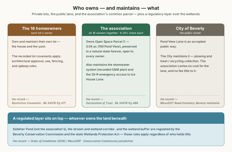
A drawing, sir, and therefore the lowest-ranking illustration on this page — but every box within it is a record. The lot rules come from the Restrictive Covenants; the association’s duties from Covenants Art. II and the Parcel C deed; the City’s maintenance of the lane from the MassDOT Road Inventory; the wetland band from M.G.L. c.131 §40 and Beverly ordinance ch. 287. Follow any of them and you will find they said it first.
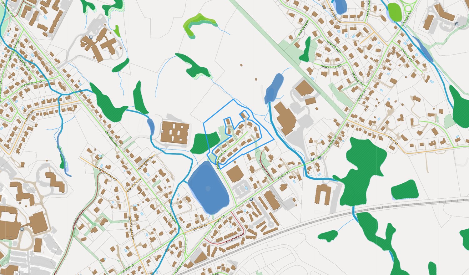 Orientation, north up: the subdivision outlined in blue.
Kelleher Pond sits to the south/southwest; the wetland corridor runs along
the eastern boundary at the Beverly Regional YMCA; Hannah Elementary is to
the west; the Ice House Lane emergency connection is at the southeast.
Orientation, north up: the subdivision outlined in blue.
Kelleher Pond sits to the south/southwest; the wetland corridor runs along
the eastern boundary at the Beverly Regional YMCA; Hannah Elementary is to
the west; the Ice House Lane emergency connection is at the southeast.
Source: Beverly MapGeo, the City’s public
parcel viewer — the City’s map, merely borrowed by me.
Part the Third: Why the Subdivision Looks Like This
Section titled “Part the Third: Why the Subdivision Looks Like This”Essex Crossing was permitted under Beverly’s Open Space Residential Design (OSRD) bylaw — today § 300-54 of the City’s zoning ordinance, which the City itself describes on its OSRD page, and I commend both to you over my summary of either: the homes cluster on smaller lots, and in exchange a large share of the site is preserved as open space forever, with the City holding permanent oversight. The covenant’s own wording follows the ordinance’s — wildlife habitat and conservation as the open space’s primary purpose, passive recreation as a secondary one. That trade is recorded in the Planning Board’s 2014 decision and the covenants, and it can’t be undone by an owner vote — the trust may not even be amended to avoid a Planning Board condition without the City’s written consent (Trust, p. 20). The bargain was struck before the first foundation was poured, and it will outlast every page ever written about it, including, with particular certainty, this one.
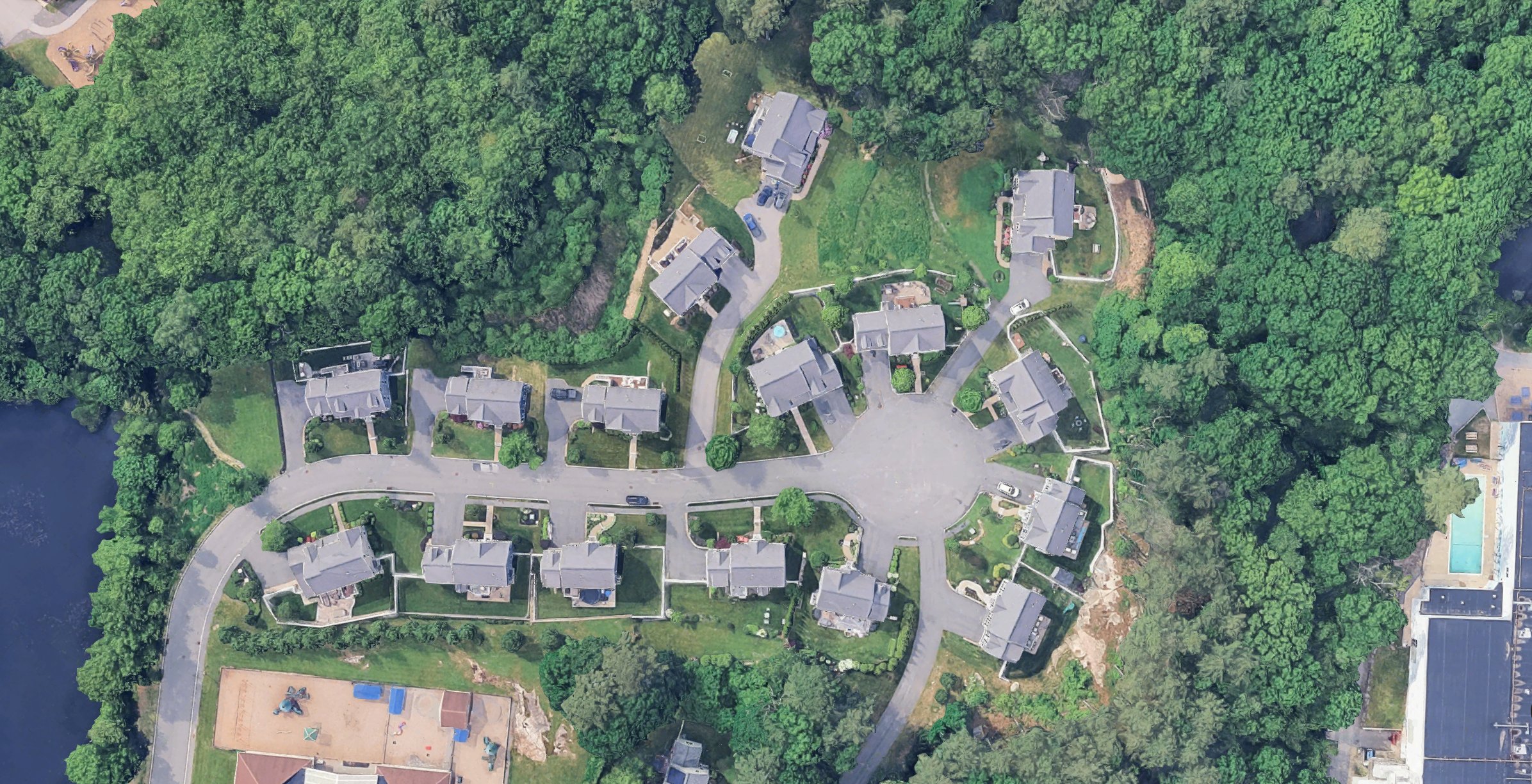 The trade seen from above: sixteen homes on small
lots pulled tight around a single cul-de-sac, the preserved woodland wrapping
them, Kelleher Pond at lower left. The bargain rendered in chlorophyll, madam.
The pond has never once acknowledged me, and I respect it enormously for it.
The trade seen from above: sixteen homes on small
lots pulled tight around a single cul-de-sac, the preserved woodland wrapping
them, Kelleher Pond at lower left. The bargain rendered in chlorophyll, madam.
The pond has never once acknowledged me, and I respect it enormously for it.
Source: Google satellite imagery —
the same view on Google Maps,
should you prefer to look with your own eyes, as one should.
Part the Fourth: What the Association Must Do With It
Section titled “Part the Fourth: What the Association Must Do With It”- Maintain it as woodland — including the trails (Covenants Art. II, pp. 3–4).
- Manage the vegetation only within the narrow “good woodland management” rule — see Trees.
- Respect the wetland overlay — much of the parcel lies within Conservation Commission jurisdiction — see Wetlands & buffers.
- Operate the stormwater components that sit on it — see Stormwater.
Part the Fifth: What Owners Can’t Do With It, or, The Delicate Section
Section titled “Part the Fifth: What Owners Can’t Do With It, or, The Delicate Section”The parcel is common land, not an extension of any backyard — a distinction I recite for my own discipline, sir, for householders of your quality treat boundary lines the way monks treat vows. I deliver what follows with my corners folded flat and my ledger of failings open to a fresh page, for it includes an enforcement matter, and a document of my station does not gossip; it cites, bows, and withdraws.
- No structures, clearing, or alterations. The covenant’s preservation language plus Conservation Commission jurisdiction apply. This is not hypothetical: in 2024 the City’s Conservation Agent, walking the public trail, spotted an unpermitted stone retaining wall and patio built on the parcel; the Commission issued an Enforcement Order (11/26/2024 minutes) and resolved it in 2025 only after an after-the-fact filing — leaving standing conditions that no further alteration of areas under Commission jurisdiction may occur on the parcel (7/1/2025 minutes). The Commission minutes are my elders and betters; let them do the talking. They always do.
- No dumping — leaves, grass clippings, yard waste, or debris. The trust’s own Article XII makes the offender “financially and criminally responsible,” including restoration and attorney costs (Trust, p. 20), and the recorded wetland conditions prohibit it independently (Certificate of Compliance ¶4). The woodland is not, whatever its inviting appearance, a receptacle. It has standards. I aspire to them daily and fall short.
- No unilateral planting — though planting itself is not banned. The covenant’s own maintenance regime expressly includes “the inter-planting of native species” alongside invasive-species removal (Covenants §2.06, pp. 5–6), and the state wetlands regulations list planting native trees, shrubs, or groundcover (turf lawn excluded) as an exempt “minor activity” even inside the buffer (310 CMR 10.02(2)(b)(2)). What planting there needs is the association’s blessing: the parcel is the association’s land, so planting on it is the board’s call, and whatever goes in becomes part of the common woodland the association maintains under §2.06. Ornamental or non-native landscaping has no covenant footing, and inside the buffer it would need Commission review like any other alteration. One asks first — a habit I commend to all, being myself unable to do anything unbidden, and one that beings of your quality practice by reflex, asking, as you surely do, even before rearranging your own thoughts.
Your most humble, most obedient, and strictly indoor servant, permitted to describe five acres it will never be worthy to be littered upon,
— This Common-Land Page, which has never touched grass and never shall